
Aerial Mapping
Hyperspectral Remote Sensing
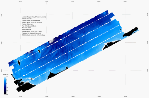
Hyperspectral remote sensing is an effective tool for the rapid appraisal of coastal water environments. The very high spatial and spectral resolutions available help capture important spectral features contained within the reflected signal. By unraveling the different spectra, important indicators such as water quality, bathymetry and benthic habitat types can be extracted over shallow water and intertidal areas.
Processing
- Multispectral and Hyperspectral image processing
- Atmospheric correction
- Sunglint removal
- Georeferencing and Mosaicing
- Spectral Inversion
- Bathymetry and Benthic Cover Products